
I am a fan of the "so what" of what we are learning about, and therefore, the students had to explain how their landforms affected the people who live near them (something we had been learning about as well.)
While learning about landforms, I created a flipped lesson about them and used real paper maps - almost ancient history these days. Please see pictures of both below, including student responses to the video.
Flipped Learning
Flipped learning - what is that? According to the Flipped Learning Network website,
"What is Flipped Learning? Flipped Learning occurs when direct instruction is moved from the group teaching space to the individual learning environment. Class time is then used for higher order, active problem solving by students and one-to-one or small group interactions with the teacher"
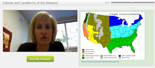
The reason I incorporate this in our classroom is to provide more class time to work with the information we are learning. Since this doesn't fit all learning styles, however, right now I am only doing one or two per unit. Here is our latest example:Climate and Landforms of the Midwest.
How do our students feel about this? Here are some of the comments they have left me:
"These videos are still awesome and it feels cool to LISTEN to your homework instead of reading it so nice job! ;)"
"I like it when you put these videos for homework. I like it because it lets us go at out own pace"
"These are a very good way to doing it. Instead of sharing this in class, just put it on the website! Its perfect."
"I really like taking notes from videos like this. I like them because I can pause and go back into the video if I need to hear something again or if I need to write something down. I also like how you include pictures of what you are explaining about. Lastly, I like having notes in this format to study from! I think this is a great way to get notes done, homework done, and to study for a test!"
Using Maps
We have spent a lot of time using maps, large paper ones in class, maps at home, maps in our textbook. These maps tell us climate zones, directions, tourist attractions, animal habitats, economic zones and country borders. The maps we used at home included Google Maps, road maps and weather maps. Hopefully we can all appreciate the use of maps outside of Social Studies class!
|


0 comments:
Post a Comment